MapSherpa Catalog
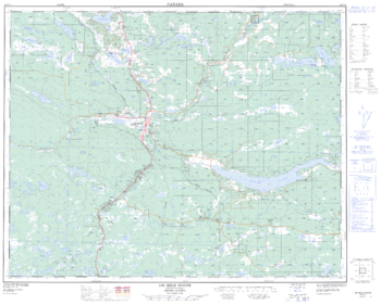
100 Mile House - 92 P/11 - British Columbia
Natural Resources Canada
Canadian topographic map of 100 Mile House, British Columbia. NTS sheet 092P11 Edition 2.
Page Size: 31.5 x 25.5 in (800 x 643 mm)
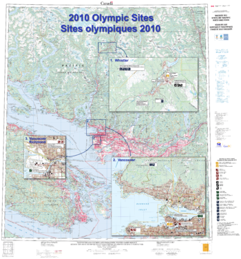
2010 Olympic sites / Sites olympiques 2010
Natural Resources Canada
Contained within the Atlas of Canada Poster Map Series, is a large-format Olympics Sites wall map (42 inches by 45 inches) featuring a 1:250 000 scale topographic base map extending from the southern tip of Vancouver Island north to Pemberton and east to Abbotsford, British Columbia. It contains inset maps, at 1:50 000 scale of Vancouver and Whistler, from the new CanTopo map series to show these areas in greater detail. Additional thematic information has been added to these insets to highlight the location of the Olympics and Paralympics sites (for example ski runs, athletes' village, hockey arena).
Page Size: 41.5 x 44.5 in (1049 x 1125 mm)

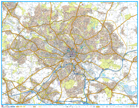
50 Miles around Birmingham Road Map
A-Z Maps
A-Z Road Map of Birmingham covers and area extending to: Chester, Congleton, Bakewell, Mansfield, Newark-on-Trent, Corby, Northampton, Milton Keynes, Aylesbury, Oxford, Cirencester, Monmouth, Hereford, Bishop's Castle, Oswestry and Wrexham.
Page Size: 49.25 x 34.5 in (1250 x 871 mm)

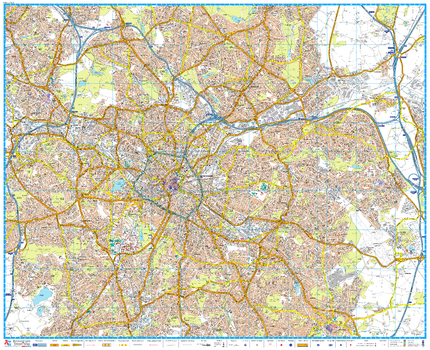
50 Miles around Manchester Road Map
A-Z Maps
A-Z Road Map of Manchester covers an area extending to: Barrow-in-Furness, Kirby Lonsdale, Ripon, York, Selby, Doncaster, Worksop, Mansfield, Nottingham, Loughborough, Cannock, Telford, Shrewsbury, Llangadfan, Rhyll, Birkenhead, Liverpool, Southport, Blackpool, Fleetwood and Lancaster.
Page Size: 48.5 x 34.5 in (1228 x 871 mm)
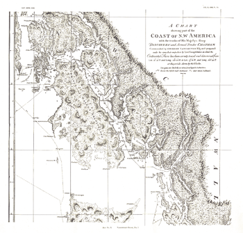
A Chart showing part of the Coast of NW America Side 1 - Published 1899
National Geographic
A Chart Showing Part of the Coast of NW America (Vancouver's Chart, No. 1) shows half of a chart of the coast of the Alaskan Panhandle and British Columbia including the Prince of Wales Archipelago, New Cornwall, and the Duke of Clarence's Strait. An antique black and white map perfect for framing, this map was published in November 1899 as half of a two-map set with the article "The Alaskan Boundary."
Page Size: 18.75 x 18 in (476 x 456 mm)
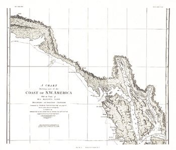
A Chart showing part of the Coast of NW America Side 2 - Published 1899
National Geographic
A Chart Showing Part of the Coast of NW America (Vancouver's Chart, No. 2) shows half of a chart of the coast of the Alaskan Panhandle and British Columbia including the Admiralty Island, Lynn Canal, and Prince Frederick's Sound. An antique black and white map perfect for framing, this map was published in November 1899 as half of a two-map set with the article "The Alaskan Boundary."
Page Size: 21 x 17.75 in (529 x 451 mm)
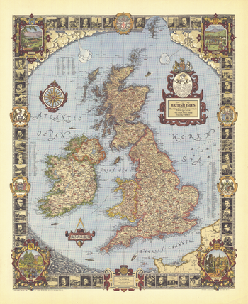
A Modern Pilgrim's Map of the British Isles - Published 1937
National Geographic
Published in June 1937, this whimsical map of the British Isles features colorful illustrations, county indexes, and thousands of places of interest in England, Wales, Scotland, and Ireland. The illustrated border contains sketches of historical figures and locations of interest. The unique artistic craftsmanship of this colorful and vibrant map make it a wonderful gift for those who love the British Isles.
Page Size: 31 x 38 in (785 x 961 mm)
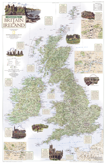
A Traveler's Map of Britain and Ireland - Published 2000
National Geographic
Rich with history and culture, Britain and Ireland remain popular destinations for tourists who are as drawn to the region's remarkable cities as they are to its iconic natural beauty. This map highlights both countries' distinctive regions and popular sites. Published in June 2000 as half of a two–map set with "The Heart of Tourist London."
Page Size: 20.25 x 31.25 in (511 x 790 mm)
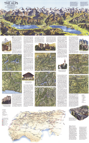
A Traveler's Map of the Alps - Published 1985
National Geographic
The top of the Traveler's Map of the Alps is dominated by a Swiss panorama, adapted from the work of Austrian landscape artist Heinrich Berann, showing the heart of the Bernese Alps, one of Europe's leading resort areas. A traveler's map shows alpine auto tours and distances and the locations of many points of interest. Seven individual maps of specific alpine regions reveal more detail. Published in April 1985, this map is half of a two-map set. Its companion map is a stunning relief map of the Alps.
Page Size: 22.5 x 36 in (570 x 912 mm)
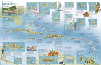
A Travelers' Map of the West Indies - Published 2003
National Geographic
The West Indies have become a popular destination for travelers who seek a little more than relaxation and fun in the sun. Yet beyond the sand, surf, and picturesque islands comes a faint echo of a bold and brutal history of colonization from the Spanish, British, Dutch, and French. Explore this beautiful and intriguing region with "A Traveler's Map of the West Indies." Published in March 2003, this map was originally printed as half of a two-piece set with a political map of the West Indies.
Page Size: 36.25 x 23.5 in (918 x 593 mm)

A World Transformed - Published 2007
National Geographic
This revealing pair of maps show the dramatic differences in Native-American and European populations along the eastern coast of North America in 1491 and 1650. Population graphics reveal changes in population from 1500 to 1800. Published in May 2007, this map represents half of a two-map set. Its companion map, "1607: When Cultures Collide," is also available.
Page Size: 20.25 x 31.25 in (511 x 790 mm)
A-Z Birmingham Street Map
A-Z Maps
A-Z Street Map of Birmingham. This map covers The National Exhibition Centre, Birmingham International Airport, Solihull (part), Yardley Wood (part), Birmingham, Smethwick, West Bromwich, Wednesbury (part), Castle Bromwich, Quinton
Page Size: 46.5 x 38 in (1180 x 960 mm)

A-Z Cardiff Street Map
A-Z Maps
A-Z Street Map of Cardiff. This map covers Cardiff, Cardiff Bay & Docks, Dinas Powys, Ely (Trelái), LLandaff,Llanishen (Llanisien), Marshfield (Maerun), Michaelston-super-Ely, Morganstown (Treforgan), Penarth, Pentyrch, Radyr (Radur), Rumney (Rhymni), St Fagans (Sain Ffagan), St Mellons, Thornhill, Wenvoe (Gwenfô), Whitchurch (Yr Eglwys Newydd).
Page Size: 46.75 x 37.75 in (1184 x 954 mm)

A-Z Central England and Wales Road Map
A-Z Maps
This A-Z Road Map of Central England and Wales is a full colour, single-sided road map featuring continuous mapping from Bristol and Reading in the south to Blackpool and Leeds in the north, and from Peterborough in the east to include the whole of Wales in the west.
Page Size: 45.75 x 35.75 in (1157 x 907 mm)

A-Z Coventry Street Map
A-Z Maps
A-Z Street Map of Coventry. This map covers Keresley Newlands, Coventry, M6 Junction 3, Walsgrave on Stowe, Binley Woods, Ryton-on-Dunsmore, Coventry Airport, Millison's Wood, Tile Hill
Page Size: 45 x 39.5 in (1138 x 1000 mm)
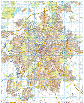
A-Z Leeds Street Map
A-Z Maps
A-Z Street Map of Leeds. This map covers Alwoodley, Beeston, Birkenshaw, Birstall (part), Bramley, Calverley, Colton, Cross Gates, Drighlington, Farsley, Gildersome, Harehills, Headingley, Horsforth, Leeds, Meanwood, Middleton, Morley, New Farnley, Oulton, Pudsey, Rawdon, Rothwell, Roundhay, Scholes, Swillington, Thorner, Woodlesford, Wortley, Yeadon (part). First edition, published August 2016.
Page Size: 46.75 x 36.25 in (1184 x 920 mm)
A-Z Leicester Street Map
A-Z Maps
A-Z Street Map of Leicester. This map covers Anstey, Belgrave, Birstall, Blaby, Braunstone Town, Cropston, Enderby, Glenfield, Glen Parva, Groby (part), Leicester, Narborough, Oadby, Syston, Thurcaston, Thurmaston, Wigston. First edition, published August 2016.
Page Size: 38.25 x 46.75 in (967 x 1184 mm)

A-Z Liverpool Street Map
A-Z Maps
A-Z Street Map of Liverpool. This map covers Aintree, Bidston, Birkenhead, Bootle, Childwall, Crosby, Halewood, Huyton, Huyton-with-Roby, Kirkby (part), Knowsley, Litherland, Liverpool, New Brighton, Prenton, Tranmere, Upton. Wallasey, Walton
Page Size: 46.75 x 37 in (1184 x 940 mm)
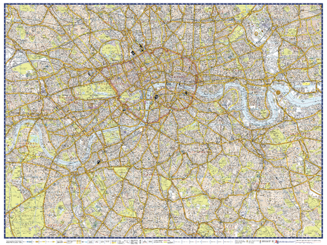
A-Z London Master Plan - Centre
A-Z Maps
A-Z Street Map of Central London. This Master Plan is one of a series of 9 street maps covering the Greater London area, which can be joined and mounted for display. Featuring A-Z's iconic street mapping, these maps include postcode district and local authority boundaries.
Page Size: 40 x 30.25 in (1015 x 763 mm)
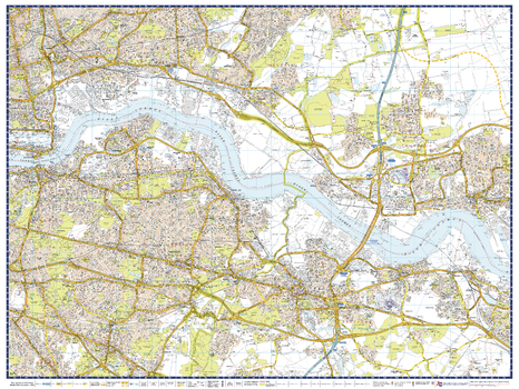
A-Z London Master Plan - East
A-Z Maps
A-Z Street Map of East London. This Master Plan is one of a series of 9 street maps covering the Greater London area, which can be joined and mounted for display. Featuring A-Z's iconic street mapping, these maps include postcode district and local authority boundaries.
Page Size: 40 x 30.25 in (1015 x 763 mm)
No search results