MapSherpa Catalog

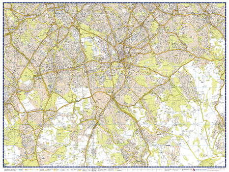
A-Z London Master Plan - North
A-Z Maps
A-Z Street Map of North London. This Master Plan is one of a series of 9 street maps covering the Greater London area, which can be joined and mounted for display. Featuring A-Z's iconic street mapping, these maps include postcode district and local authority boundaries.
Page Size: 40 x 30.25 in (1015 x 763 mm)
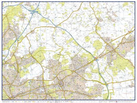
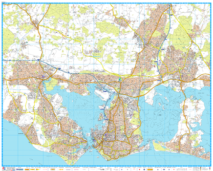
A-Z London Master Plan - North East
A-Z Maps
A-Z Street Map of North East London. This Master Plan is one of a series of 9 street maps covering the Greater London area, which can be joined and mounted for display. Featuring A-Z's iconic street mapping, these maps include postcode district and local authority boundaries.
Page Size: 40 x 30.25 in (1015 x 763 mm)

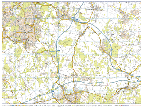
A-Z London Master Plan - North West
A-Z Maps
A-Z Street Map of North West London. This Master Plan is one of a series of 9 street maps covering the Greater London area, which can be joined and mounted for display. Featuring A-Z's iconic street mapping, these maps include postcode district and local authority boundaries.
Page Size: 40 x 30.25 in (1015 x 763 mm)
A-Z London Master Plan - South
A-Z Maps
A-Z Street Map of South West London. This Master Plan is one of a series of 9 street maps covering the Greater London area, which can be joined and mounted for display. Featuring A-Z's iconic street mapping, these maps include postcode district and local authority boundaries.
Page Size: 40 x 30.25 in (1015 x 763 mm)
A-Z London Master Plan - South East
A-Z Maps
A-Z Street Map of South East London. This Master Plan is one of a series of 9 street maps covering the Greater London area, which can be joined and mounted for display. Featuring A-Z's iconic street mapping, these maps include postcode district and local authority boundaries.
Page Size: 40 x 30.25 in (1015 x 763 mm)

A-Z London Master Plan - South West
A-Z Maps
A-Z Street Map of South West London. This Master Plan is one of a series of 9 street maps covering the Greater London area, which can be joined and mounted for display. Featuring A-Z's iconic street mapping, these maps include postcode district and local authority boundaries.
Page Size: 40 x 30.25 in (1015 x 763 mm)

A-Z London Master Plan - West
A-Z Maps
A-Z Street Map of West London. This Master Plan is one of a series of 9 street maps covering the Greater London area, which can be joined and mounted for display. Featuring A-Z's iconic street mapping, these maps include postcode district and local authority boundaries.
Page Size: 40 x 30.25 in (1015 x 763 mm)
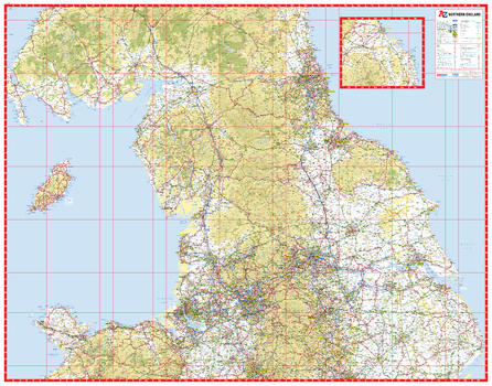
A-Z Northern England Road Map
A-Z Maps
This A-Z Road Map of Northern England is a full colour, single-sided road map featuring continuous mapping from Stoke-on-Trent in the south to Alnwick in the north and the Isle of Man in the west to Skegness on the east coast. An inset map extends coverage northwards to include Berwick-Upon-Tweed, Holy Island and Seahouses.
Page Size: 45.75 x 35.75 in (1157 x 907 mm)

A-Z Plymouth Street Map
A-Z Maps
A-Z Street Map of Plymouth. This map covers Plymouth, Tamerton Foliot, Southway, Roborough, Derriford, Woodford, Plympton, Brixton, Plymstock, Devonport, St.Budeaux
Page Size: 47 x 37.75 in (1189 x 957 mm)
A-Z Portsmouth Street Map
A-Z Maps
A-Z Street Map of Portsmouth. The map covers Fareham, Wymering, Waterlooville, Horndean, Rowland's Castle, Havant, Hayling Island, Portsmouth, Gosport, Lee-on-the-Solent, Stubbington, Catisfield. First edition, published July 2017.
Page Size: 47 x 37.75 in (1189 x 955 mm)

A-Z Sheffield Street Map
A-Z Maps
A-Z Street Map of Sheffield. This map covers Aston, Attercliffe, Beighton, Brinsworth, Grenoside, Hackenthorpe, Killamarsh, Kimberworth, Moorgate, Mosborough, Oughtibridge, Owlerton, Parson Cross, Rotherham, Sheffield, Stannington, Swallownest, Tapton Hill, Templeborough, Walkley, Whiston, Wickersley, Wincobank
Page Size: 47 x 36.25 in (1189 x 915 mm)

A-Z South East and Central England Road Map
A-Z Maps
This A-Z Map of South East & Central England is a full colour, single-sided road map featuring continuous mapping from Nottingham to the south coast, including the Isle of Wight, and from Cardiff to the east coast.
Page Size: 45.75 x 35.75 in (1157 x 907 mm)
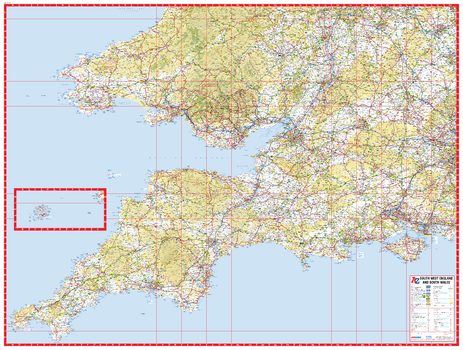
A-Z South West England and South Wales Road Map
A-Z Maps
This A-Z sheet map of South West England and South Wales is a road map extending from Land's End and St. David's Head in the west to Aberystwyth in the north and Chichester in the south east.
Page Size: 45.75 x 34.5 in (1157 x 876 mm)

A-Z Southampton Street Map
A-Z Maps
A-Z Street Map of Southampton. This map covers Botley, Chandlers Ford, Colden Common, Eastleigh (part), Hamble-Le-Rice, Hythe, Netley Abbey, Park Gate, Romsey, Rownhams, Southampton, Titchfield, Totton, Warsash, Whiteley, Woolston
Page Size: 41.5 x 40 in (1051 x 1013 mm)
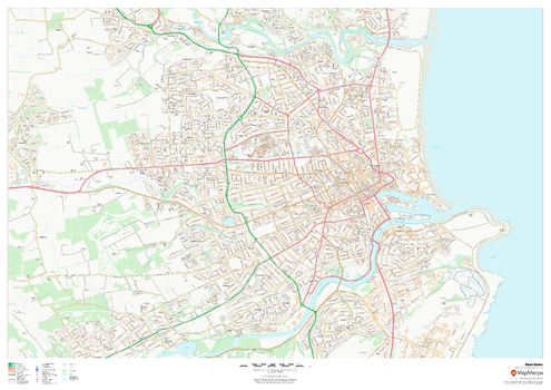
Aberdeen
MapSherpa
This map of Aberdeen shows detailed street level information including extensive street labelling. Ideal for planning of deliveries, home services, sales territories, real estate and much more.
Page Size: 47 x 33.25 in (1189 x 841 mm)

Aberdeen - AB - Postcode Wall Map
XYZ Maps
The Aberdeen Postcode Sector Wall Map clearly shows detailed postcode sector boundaries (AB1 1, AB1 2) on a comprehensive background and is perfect for determining postcode boundaries for sales areas, planning mailshots and also an excellent reference for logistics. This wall map covers the whole of the AB Postcode Area.
Page Size: 47 x 33.25 in (1189 x 841 mm)
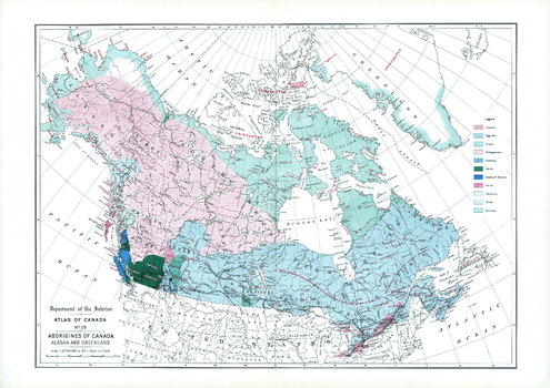
Aborigines of Canada, Alaska and Greenland (1906)
Natural Resources Canada
Contained within the 1st Edition (1906) of the Atlas of Canada is a map that shows the distribution of 11 aboriginal groups of Canada, Alaska and Greenland. The areas shown in different colours represent occupied land by the native linguistic families, including uninhabited large areas in the Arctic islands and Greenland. The southern portion of Canada, the Indians are living on reserves. The other points indicated are small reminants of the once powerful Huron-Iroquois at Jeune Lorette, two small bands of Iroquois near Edmonton and on the head waters of the Athabaska river. There are a greater number of linguistic families on the Pacific coast of British Columbia than in all the rest of Canada.
Page Size: 24.25 x 17.25 in (613 x 433 mm)
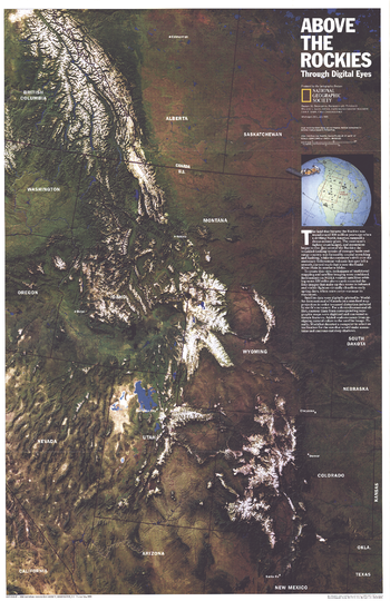
Above the Rockies - Published 1995
National Geographic
NOAA satellite imaging formed the basis of this fascinating map of the Rocky Mountain region which was then computer-enhanced by WorldSat International of Canada. Published in July 1995, this map accompanied the "Heart of the Rockies" tourist map.
Page Size: 20.25 x 31.25 in (513 x 792 mm)
Acorn Hollow Quadrangle, California
United States Department of Agriculture Forest Service
United States Department of Agriculture Forestry Service topographical map of Acorn Hollow, Lassen National Forest, California.
Page Size: 21.75 x 27 in (552 x 686 mm)
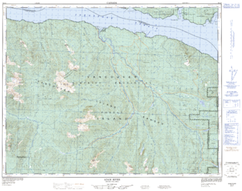
Adam River - 92 L/8 - British Columbia
Natural Resources Canada
Canadian topographic map of Adam River, British Columbia. NTS sheet 092L08 Edition 3.
Page Size: 32 x 25.25 in (812 x 641 mm)
No search results